Oldalak

2024-12-14

Hozzájárulási lehetőség tudományos folyóiratok tematikus különszámaihoz az ISPRS IV. szakbizottságán keresztül

Prof. Dr. Sisi Zlatanova (SHARP Professor, GRID, FBE, UNSW ) tette közzé a Linkedin hálózatán a honi szakmai közösség érdeklődésére is számot tartó figyelemfelhívást: "A little more than a month ago we had the very successful ISPRS TCIV Symposium in Fremantle (https://lnkd.in/ge3VDZBJ). As a result of an excellent collaboration with several Scientific journals, we have initiated five special issues in different areas of spatial information sciences: 1. ISPRS International Journal of Geo-Information (IF 3.4): "Spatial Information for Improved Living Spaces", Deadline: 25 October 2025 link: https://lnkd.in/gFGTSrbz, 2. Journal of Spatial Science: "Visualization and Virtual Restoration of Cultural Heritage", Deadline: 10 March 2025 Link: https://lnkd.in/g6Wz3EzG 3. Geo-spatial Information Science: "3D Digital Modelling with Domain Knowledge", Deadline: 01 May 2025 Link: https://lnkd.in/giamSD2Z 4. Smart Cities: "Computer Vision for Creating Sustainable Smart Cities of Tomorrow", Deadline 15 August 2025 Link: https://lnkd.in/g3DWnZu3, 5. International Journal of Applied Earth Observation and Geoinformation & Geomatica: "Urban Digital Twins: Innovative geospatial solutions, Applications, and Future Trends", Deadline 01 May 2025 Link: https://lnkd.in/ghJGs_c6 Please feel free to contact the Editors of Special issues for any further inquiries. ISPRS International Journal of Geo-Information mdpi.com"

A Nemzetközi Digitális Föld Társaság 14. Nemzetközi Szimpóziuma a szecsuáni Chongqingban!

A Nemzetközi Digitális Föld Társaság felhívása! (A meghirdetett rendezvény nemzetközi tudományos bizottságának tagja Prof.Dr. Szabó Szilárd a Debreceni Egyetem Természetföldrajzi és Geoinformatikai Tanszék vezetője.)


Dear Colleagues,

We are excited to announce the 14th International Symposium on Digital Earth (14th ISDE), which will be held from April 21 to 25, 2025, in Chongqing, China. The International Symposium on Digital Earth is one of the most prestigious conference series organized by ISDE, having successfully hosted 13 Symposia across 10 countries, drawing tens of thousands of scholars, government officials, and business people from over 70 countries and regions.

With support of a multitude of international partners and co-organizers, the 14th ISDE is meant to be an exceptional platform for exploring the dynamic landscape of digital transformation, comparing notes on the evolving concept of Digital Earth, and envisioning pathways toward global sustainability. We invite you to join us and help spread the invitation to your network.

Theme: Digital Earth Facilitating Sustainable Development Goals
Date: April 21-25, 2025
Location: Chongqing, China

Organizers
International Society for Digital Earth
Southwest University

Hosts
Chinese National Committee of International Society for Digital Earth
International Research Center of Big Data for Sustainable Development Goals
School of Geographical Sciences, Southwest University
Chongqing Yuelai Liangjiang International Hotel Conference Management Co., Ltd.

Topics: (including but not limited to)
  • Theories, Models, and Key Technologies of Digital Earth
  • Big Earth Data Sharing, Applications, and Services
  • Demonstrative Applications in the Field of Digital Earth
  • Digital Earth for Supporting the Achievement of Sustainable Development Goals
  • Development of Digital Earth Industry and Enterprises
  • Digital Earth Supporting Innovation and Development of Countries along the Belt and Road Initiative

Call for Sessions
We are now inviting proposals for the organization of specialized sessions. Each session should be organized by 2-4 conveners (who will, in principle, serve as co-chairs). Sessions will run for 2 hours and may include 8-10 oral presentations, with each presentation lasting 15 minutes, including 2-3 minutes for questions.

Please submit your session proposal by December 6, 2024 at https://isde2025.event.evtr.cn. After review and approval by the organizing committee, session conveners will be notified, and session topics will be posted on the conference website.

Call for Abstract
The conference will feature oral presentations (including plenary invited talks and session presentations) and poster sessions. Representatives giving session oral presentations and poster presentations are required to register for the conference and submit an abstract online (in English). When submitting the abstract, please select the relevant session topic. After review and approval by the organizing committee, authors will be notified.

Important Dates
  • December 6, 2024   Session Submission Deadline
  • January 20, 2025    Abstract Submission Deadline
  • January 31, 2025    Abstract Acceptance Notification
  • March 15, 2025       Early Bird Registration Deadline

Sponsorship and Exhibition
Industry enterprises in the field of Digital Earth are warmly invited to sponsor the conference. In addition, a technology exhibition will be held during the conference. For details on sponsorship and exhibition opportunities, please refer to the conference website.

Contact Us
Conference Secretariat:

Website: https://isde2025.event.evtr.cn


2024-11-21

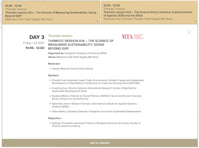
Prof. Huadong Guo előadása a budapesti Tudományos Világfórum tematikus szekciójában november 22-én délelőtt (Digitális technológiákkal a Fenntartható Fejlődési Célok eléréséért).

 World Science Forum 2024 Budapest

A megkezdődött többnapos nemzetközi tudományos nagyrendezvény (https://worldscienceforum.org) élő videó adásban is nyomon követhető.

Holnap, pénteken, előadást tart Prof.Huadong Guo kínai akadémikus, aki a hazai térinformatikai-űrkutatási szakmai közösséggel 2003 óta tart kapcsolatot a Nemzetközi Digitális Föld Társaságon keresztül. Intézete (International Research Center of Big Data for Sustainable Development Goals) tudományos tanácsadója az MFTTT WG4SDG vezetője, Dr.Mihály Szabolcs.

Hivatalos leírás az előadó bemutatásával és  előadásának tárgyáról itt található: https://worldscienceforum.org/speakers/guo-huadong-58283

A rendezvény figyelemfelhívó grafikája (WSF)


2024-10-23

Életfa emlékplakett


Az 1956-os Forradalom és Szabadságharc Emléknapja, október 23-a alkalmából Dr. Nagy István miniszter úr az Életfa Emlékplakett Ezüst fokozatában részesített a földügyi-térképészeti szakterület informatikai fejlesztése érdekében végzett munkámért. Külön szakmai elismerés, hogy a felterjesztést Zalaba Piroska, az Agrárminisztérium Földügyi és Térinformatikai osztályvezetője javasolta és készítette elő. Az ágazat Életfa elismeréseit (1 gyémánt, 3 arany, 8 ezüst és 9 bronz fokozatban), szakmai kitüntetéseit és a miniszteri dicséretek okleveleit Farkas Sándor miniszterhelyettes úr adta át ünnepi kultúrprogram keretében és állófogadással egybekötve a Mezőgazdasági Múzeum patinás épületében.


Fotó: Pelsőczy Csaba, AM Sajtóiroda

Fotó: Pelsőczy Csaba, AM Sajtóiroda


A két utolsó fénykép forráshelye:

https://kormany.hu/hirek/hit-remeny-szabadsag-56-szelleme-elni-fog-a-szabad-emberek-es-nemzet-emlekezeteben


2024-09-30

Előkerült szakmapolitikai dokumentum: hivatalos felkérő levél a GSDI vezetőségétől a nemzetközi kezdeményezés tanácsadói szerepkörére (1998)

1996 tavaszán a két éve működő HUNAGI az FVM, OMFB támogatásával, és az EUROGI elnökének, az ír Mike Brand  közbenjárására részt vehetett Königswinterben a Globális Téradat Infrastruktúra (GSDI) kezdeményezés első nemzetközi konferenciáján. A nemzetközi kezdeményezés Martin Bangemann az Európai Bizottság tagja (DG III) és Bruce Babitt az Egyesült Államok Belügyminisztere (USGS felügyeleti szerve) védnökségével Észak-Karolina és Északrajna-Vesztfália együttműködésével indult. Igy került a GSDI vezetőségébe Észak-Karolina kormányzójának tudomány- és technológiai vezető tanácsadója J.S.Patterson, aki az első két GSDI konferencia magyar résztvevőjét az alábbi levélben hívta meg a kezdeményezés vezetésének tanácsadói szerepkörére. HUNAGI ettől kezdve kivette a részét a GSDI szervezeti megalakításának előkészítésében. A kezdeményezés európai bajnoka a Bad Godesberg-i Északrajna-Vesztfália tartományi földmérési-térképészeti hivatal akkori vezetője Klaus Barwinski volt, aki a CERCO, EUROGI és GSDI szervezetek kimagasló személyisége volt.


2024-09-05

Idén 20 éves a Nemzetközi Digitális Föld Társaság (ISDE). A társaság egyes jelenlegi és korábbi vezetőségi tagjának évfordulós köszöntése.

A Nemzetközi Digitális Föld Társaság idén ünnepli 20 éves fennállását. Ez alkalomból Prof. Wang Changlin főtitkártól a következő üzenetet kaptam Pekingből: "Dear ISDE Colleagues, I’m excited to share that we’re celebrating the 20th anniversary of ISDE this year, and I’d love for you to be a part of it. It’s a great milestone for us, and working with you has been a fantastic journey. A big THANK YOU to each and every one of you for your valuable contributions over the years. We put together a special webpage to showcase what we’ve achieved together. Check it out here: https://www.digitalearth-isde.org/list-110-1.html. We get some more events for the coming months to mark this occasion. It would be great to have you with us, and please feel free to share the announcement below with your colleagues. Look forward to celebrating with you and to many more milestones ahead! Best regards, Changlin Wang, Prof. Dr. ----------------- WANG Changlin, Prof. Dr. Secretary General, International Society for Digital Earth (Affiliated Member, International Science Council) Executive Editor-in-Chief, Big Earth Data Journal (ESCI IF 4.0, EI, Scopus, DOAJ) Executive Editor-in-Chief, International Journal of Digital Earth (SCIE IF 5.1) Aerospace Information Research Institute, CAS No.9 DengZhuangNanLu,Haidian District,Beijing 100094, China"

2024-08-25

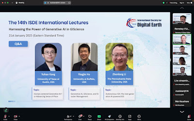
12. ISDE Nemzetközi Előadások: Világméretű, élelmiszer- és vízbiztonság támogatás többszenzoros távérzékeléssel, gépi tanulással és mesterséges intelligenciával. Előadók a USGS-től. 2024

Az ISDE Titkárságról augusztus 19-én érkezett körlevél megosztása       (Megjegyzés: az időeltolódás a PST-től nálunk +9 óra):

"Dear Colleagues,

You are cordially invited to participate in the 12th ISDE International Lectures, with the theme of "Global Food-and-Water Security-support Analysis Data Using Multi-sensor Remote Sensing, Machine Learning, and AI on the Cloud". The event will invite three speakers to share their research results about the Global Food-and-Water Security-support Analysis Data (GFSAD), Landsat-Derived Global Rainfed and Irrigated-Cropland Product @ 30m for USA (LGRIP30-USA), and crop type mapping using machine learning and AI on the cloud.

Theme: Global Food-and-Water Security-support Analysis Data Using Multi-sensor Remote Sensing, Machine Learning, and AI on the Cloud

Date & Time:
9th September, 2024, 18:00-19:30 (USA Pacific Standard Time)
10th September, 2024, 9:00-10:30 (China Standard Time)


Organized by: International Society for Digital Earth
Supported by: International Research Center of Big Data for Sustainable Development Goals, International Journal of Digital Earth, Big Earth Data

Zoom Link:
Az elérhetőség érdekében lépjen kapcsolatba az ISDE titkárságával
https://www.digitalearth-isde.org/show-48-329-1.html

Invited Speakers:
Prasad S. Thenkabail (United States Geological Survey)
Pardhasaradhi Teluguntla (United States Geological Survey)
Itiya Aneece (United States Geological Survey)

Moderator:
Prasad S. Thenkabail (United States Geological Survey)

Programme: (USA Pacific Standard Time, PST)
18:00-18:05 Welcome and Introduction
18:05-18:25
  • Topic: Global Food-and-Water Security-support Analysis Data (GFSAD)
  • Speaker: Prasad S. Thenkabail (United States Geological Survey)
18:25-18:45
  • Topic: Landsat-Derived Global Rainfed and Irrigated-Cropland Product @ 30m for USA (LGRIP30-USA)
  • Speaker: Pardhasaradhi Teluguntla (United States Geological Survey)
18:45-19:05
  • Topic: Crop Type Mapping Using Machine Learning and Artificial Intelligence on the Cloud
  • Speaker: Itiya Aneece (United States Geological Survey)
19:05-19:30 Group Photo and Q&A

For more information about the 12th ISDE International Lectures, please visit:
https://www.digitalearth-isde.org/show-48-329-1.html

If you want to give lectures here in the future, please visit:
http://www.digitalearth-isde.org/show-54-220-1.html

Best regards,
Secretariat of International Society for Digital Earth
No.9 Dengzhuang South Road, Haidian District, Beijing 100094, China

ISDE Website: www.digitalearth-isde.org
LinkedIn @International Society for Digital Earth
Facebook @International Society for Digital Earth
Twitter @ISDEsecretariat
YouTube @isde_digitalearth"

To view this discussion on the web, visit https://groups.google.com/d/msgid/isde-publication-community/80e1faa9-1559-4234-9df0-3a000ab39238n%40googlegroups.com.

Megjegyzés: AZ USGS siouxfallsi EROS adatközpontja globális, történelmi idősorokkal rendelkezik 1972 óta a Landsat felvételekből. Az illusztráció az adatközpontot mutatja egy képeslap részleten amikor a CEOS WGISS ülésének adtak otthont.


2024-07-19

Magas színvonalú tudományos lapokban való publikálás innovatív perspektívái és gyakorlati tapasztalatai - ISDE előadások

Az érdekeltek figyelmébe! A Nemzetközi Digitális Föld Társaság (ISDE) Titkársága körlevélben tette közzé soron következő on-line előadásait, amelyek a kutatók publikálási gyakorlatát fejleszthetik.

'You are cordially invited to participate in the 11th ISDE International Lectures, with the theme of "Innovative Perspectives and Practical Experience of Publishing Scientific Papers in Top Journals". The event will invite two speakers to share their extensive scientific research experience, and provide unique insights into academic writing and guidance on publishing compelling papers in top-tier journals.

Theme: Innovative Perspectives and Practical Experience of Publishing Scientific Papers in Top Journals

Date & Time:
25 July 2024, 19:00-20:30 (Pacific Daylight Time)
26 July 2024, 10:00-11:30 (China Standard Time)


Organized by: International Society for Digital Earth

Supported by: Beijing International Science and Technology Exchange Center, International Research Center of Big Data for Sustainable Development Goals, International Journal of Digital Earth, Big Earth Data

Zoom Link:
https://us06web.zoom.us/j/85279093503?pwd=lhpmMDyc3XinyYAhpoDO7Ox0aRBR6L.1
Az esemény azonosító és a szükséges jelszó a levél végén található honlapcímen kérhető meg.

Invited Speakers:
Baojing GU (Zhejiang University, China)
Shuli CHEN (University of Arizona, USA)

Programme: (Pacific Daylight Time)
19:00-19:05 Welcome and Introduction
19:05-19:35
  • Topic: Research experience sharing and insights into publishing in top journals
  • Speaker: Baojing GU (Zhejiang University, China)
19:35-20:05
  • Topic: Amazon forest biogeography predicts resilience and vulnerability to drought
  • Speaker: Shuli CHEN (University of Arizona, USA)
20:05-20:30 Group Photo and Q&A

For more information about the 11th ISDE International Lectures, please visit:

2024-05-27

GeoAI alkalmazása a távérzékelt adatok elemzésében. IEEE GRSS/ISDE-YSIN szimpózium benne Dr. Bertalan László ISDE-YSIN tag előadásával. Ingyenes on-line hozzáférhetőség: május 28-29.

A Digitális Föld Nemzetközi Társaság titkárságának körleveléből:

"The 1st IEEE GRSS/ISDE-YSIN Symposium on GeoAI for Remote Sensing Data Analysis will be held both physically at the Faculty of Sciences, Chouaib Doukkali University, El Jadida, Morocco, and virtually from May 28-29, 2024.


The Symposium aims to enhance connections and promote knowledge sharing within the geoscience and remote sensing community. This event builds upon the serial ISDE Lecture on the Digital Earth Youth Innovation, encouraging greater collaboration and communication to facilitate the exchange of research insights and ideas among members of both IEEE GRSS and ISDE-YSIN. You’re cordially invited to attend this event and share your valuable thoughts and findings.

Organized by:
IEEE Geoscience and Remote Sensing Society (IEEE GRSS) Moroccan Chapter
International Society for Digital Earth - Young Scientist Innovation Network (ISDE-YSIN)
Chouaib Doukkali University, Morocco

Schedule:
9:00 - 10:00 (WAT) / 10:00 - 11:00 (CET), May 28, 2024
Welcome Ceremony with opening remarks from both ISDE and IEEE Presidents

10:30 - 18:15 (WAT) / 11:30 - 19:15 (CET), May 28, 2024
Full-day Symposium including 6 presentations by ISDE-YSIN members as follows:

- Title: Cross-disciplinary geospatial studies in the era of AI
- Presenter: Prof. Siqin Wang, Spatial Sciences Institute, University of Southern California, USA

- Title: Geospatial Artificial Intelligence Applications with Remotely Sensed Data
- Presenter: Prof. Elif Sertel, Istanbul Technical University, Turkish

- Title: Cartography and geomatics in Education
- Presenter: Prof. Yana Lipiyska, Faculty of Geodesy, University of Architecture, Civil Engineering and Geodesy, Sofia, Bulgaria

- Title: Monitoring and Detection: Earth Observation and Remote Sensing Techniques for Heritage Sites and Monuments
- Presenter: Prof. Athos Agapiou, Cyprus University of Technology, Cyprus

- Title: Close-range remote sensing to assess changes in rivers, soils, and plants
- Presenter: Prof. László Bertalan, Department of Physical Geography and Geoinformatics, University of Debrecen, Hungary

- Title: Urban Forests in Support of Sustainable and Equitable City Development
- Presenter: Prof. Lin Jian, School of Geography, Nanjing Normal University, China

12:00 - 17:00 (WAT) / 13:00 - 18:00 (CET), May 29, 2024
Online Training Workshop on GeoAI for remote sensing using KNIME software

Online Meeting Link: https://usc.zoom.us/j/98719072500?pwd=dllLZnRvUUN1MXFteW1taDJhMEhvUT09

Participation Fees: Free of charge

For any inquiries, please reach out to grsschapt...@gmail.com. More details are available at https://bit.ly/3vXq8Vl.

Looking forward to your participation.

Best regards,
Secretariat of International Society for Digital Earth
No.9 Dengzhuang South Road, Haidian District, Beijing 100094, China

ISDE Website: www.digitalearth-isde.org
LinkedIn @International Society for Digital Earth
Facebook @International Society for Digital Earth
Twitter @ISDEsecretariat
YouTube @isde_digitalearth "

A körlevelek címlistájára fel lehet. iratkozni.


2024-05-26

Hozzájárulás a HUNAGI 2024.évi 36. Közgyűléséhez

 A szervezet elnökének, közgyűlésre meghívott tagjainak előzetesen megküldött levelemben az alábbi javaslatot adtam:

"

Tisztelt Elnök Úr!

Kedves Zsolt!


Köszönöm a 36. HUNAGI közgyűlésre szóló meghívót (az eredetit én sem kaptam meg).

Minthogy egészségügyi okból továbbra sem lehetséges, hogy személyesen részt vegyek, ezért mint a legutóbbi közgyűlések esetében, előzetesen megküldött véleményemmel, javaslatommal kívánom segíteni a találkozó munkáját.


Nincs kétségem: a HUNAGI kompetens tagszervezetei és képviselőik biztosítékot jelenthetnek arra, hogy a Társaság sikeresen alapozza meg működését fennállása 3. évtizedére is.


Ezt igazolja a 2023.évi beszámoló, amelyből több ígéretes területen a szakértő tagszervezeti képviselők aktivitása kiolvasható.


Tekintettel arra, hogy a földmegfigyelési információs rendszerek és szolgáltatások területének is szakavatott és tapasztalt képviselői vannak jelen a HUNAGI-ban is, az a javaslatom, hogy a 2024.évi munkaterv keretében ismerjék meg a CEOS WGISS munkacsoportjának tevékenységét a csatolt, legfrissebb dokumentum tanulmányozásával.

Véleményem szerint célszerű ugyanis megfontolni a munkába való bekapcsolódás előnyeit és lehetőségét.

Megjegyzem, éppen a HUNAGI kivívott nemzetközi hírneve, tagjainak eredménye vezetett oda, hogy 2006-ben a HUNAGI tisztségviselőjét jelölték az akkor ESA és NASA vezetésével működő WGISS munkacsoport és a GSDI szervezet közötti állandó összekötőnek. A GSDI 2018.évi megszűnésétől kedve a magyar részvétel a WGISS-ben a KKM illetékes főosztálya hozzájárulásával volt lehetséges, de a COVID óta a személyes, aktív részvételre már nem kerülhetett sor. A WGISS a földmegfigyelési információs rendszerek és szolgáltatások olyan gyakorlati kérdéseivel foglalkozik, amelyek a hazai űrtevékenységek fejlesztését a felújítandó nemzetközi együttműködés révén meggyőződésem, hogy előmozdítja. A CEOS WGISS jelenlegi vezetését a USGS látja el, a soron következő találkozó az EROS Adatközpontban lesz az év utolsó negyedévében (az aktív bekapcsolódáshoz táv-részvételt is elfogadnak). Ha igény van rá, tapasztalataimat örömmel átadom.

Jelen levelet és csatolmányát szíves tájékoztatásul és felhasználásra küldöm a t. Címzetteknek, másolatban azoknak, akikkel e tématerületen kapcsolatban álltam.


Eredményes 36. Közgyűlést kívánok!

Üdvözlettel,

Dr. Remetey-Fülöpp Gábor


Ui.: 2023-ban nem kaptam értesítést a tagdíj befizetésére. Kész vagyok rendezni az ideivel együtt, ha kapok értesítést."

(Megjegyzés: a becsatolt, nevemre érkezett 100+ oldalas tartalmas dokumentum hozzáférhető a CEOS honlapján ..A levél másolatban eljutott a KKM Űrtevékenységért és Űrpolitikáért Felelős Főosztály munkatársához is)

2024-04-03

VISSZATEKINTÉS: Figyelemfelhívás az OMFB elnökhelyettese számára Clinton elnök Nemzeti Téradat Infrastruktra rendeletéről

30 évvel ezelőtt, az Európai Bizottság információtechnológiai főigazgatóságáról (DGXIII) feladott telex tartalmazta azt az 1994. áprilisi USA elnöki rendelet szövegét, melyet a Fehér Ház tett közzé. Ez a dokumentum előbb-utóbb világszerte kihatott a téradatok interoperábilis szolgáltatására és felhasználására. A telex címzettje Bottka Sándor OMFB elnökhelyettese volt, de azt másolatban megkapta Detrekői Ákos akadémikus, műegyetemi professzor, az MFTTT és HUNGIS Alapítvány elnöke is. Ugyanabban az évben alakult meg az OMFB, FVM és BME/MTA támogatásával a Magyar Térinformatikai Társaság, a HUNAGI.

2024-03-13

VISSZATEKINTÉS 1990 októbere Az USDA-FM/FÖMI tudományos együttműködés tanulmányúti programja (Földmegfigyelés, térinformatika, éghajlatváltozás, intézményközi együttműködés)

A 34 évvel ezelőtti egyhetes tudományos program USDA dokumentumának másolata és egy kapcsolódó, ma méginkább aktuális tárgyú konferencia FM-be érkezett figyelemfelhívó anyaga és a rendezvény előadáskötete.

Jelenlegi trendek és kutatási irányzatok - 'Digital Twins' technológia a fenntartható fejlődési célok monitoringjában. Cikkeket várnak Big Earth Data szakfolyóirat különszámába.

Figyelemfelhívás a Nemzetközi Digitális Föld Társaságtól (ISDE). Érdeklődés esetén lépjen kapcsolatba az ISDE Titkársággal. A Big Earth Data szakfolyóiratnak szerkesztőbizottsági tagja is van: Prof.Dr.Szabó Szilárd, a Debreceni Egyetemről! "The journal Big Earth Data is now calling for papers for a Special Issue on Exploring Recent trends and research trajectories in Digital Twins technology for monitoring of Sustainable Development Goals. We cordially invite contributions to this prestigious Special Issue which focuses on collecting advanced developments, innovative methods of modelling/generating digital twins in urban area, for example, semantic segmentation and object detection for city objects from image and/or Lidar point clouds data, the extraction and regularization of polygons as outline of objects for 3D modelling into digital twins. For detailed information about the Special Issue, please click here. (Elérhetőség: ISDE honlap, Big Earth Data folyóirat) Submission Instructions Please visit the Instructions for Authors page before submitting your manuscript. Important Dates 30 September, 2024 Paper submission online 31 October, 2024 Decision to authors 30 November, 2024 Revised paper submission 31 December, 2024 Publication Submission Portal Once you have finished preparing your manuscript, please submit it through the Taylor & Francis Submission Portal, ensuring that you select the appropriate Special Issue. Publication charges (APCs) will be waived for invited manuscripts submitted to Big Earth Data. About Big Earth Data Big Earth Data is an interdisciplinary open access academic journal jointly published by the International Society for Digital Earth, International Research Center of Big Data for Sustainable Development Goals, Aerospace Information Research Institute, Chinese Academy of Sciences, and Taylor & Francis Group. Prof. Huadong Guo is the Editor-in-Chief of the journal. Big Earth Data is the world's first big data journal in the Earth sciences, and it aims to provide an efficient and high-quality platform for promoting "big data" sharing, processing and analyses, thereby revolutionizing the cognition of the Earth's systems. The journal publishes research articles, review articles, data articles and technical notes on "big data" studies across the entire spectrum of the Earth sciences. The journal is indexed in Scopus (CiteScore=8.0), ESCI (IF=4.0), Ei Compendex and Inspec. Best regards, Secretariat of International Society for Digital Earth No.9 Dengzhuang South Road, Haidian District, Beijing 100094, China ISDE Website: www.digitalearth-isde.org LinkedIn @International Society for Digital Earth Facebook @International Society for Digital Earth Twitter @ISDEsecretariat YouTube @isde_digitalearth "

2024-03-11

Újabb ISDE tematikus előadások a nagytömegő adatok elemzése, modellmegosztások a Digitális Föld kontextusában március 27-én. Jelentkezés az ISDE Titkárságon keresztül

Részlet a Nemzetközi Digitális Föld Társaság (ISDE) legutóbbi körleveléből, melyet a regisztrált érdeklődők számára küldtek. "You are cordially invited to participate in the 9th ISDE International Lectures, with the theme of "Scientific Model Sharing for the Digital Earth". The event will invite three speakers to provide their perspectives on the big earth data analytics, open model sharing, and model sharing facilities. Theme: Scientific Model Sharing for the Digital Earth Date & Time: 27 March, 2024, 9:00 - 10:30 am (CET) Organized by: International Society for Digital Earth Supported by: International Research Center of Big Data for Sustainable Development Goals, International Journal of Digital Earth, Big Earth Data Zoom Link: az ISDE titkárságtól kérhető meg. http://www.digitalearth-isde.org/show-48-305-1.html Invited Speakers: Stefano Nativi (National Research Council of Italy) Paolo Mazzetti (National Research Council of Italy) Mattia Santoro (National Research Council of Italy) Moderator: Paolo Mazzetti (National Research Council of Italy) Programme: 9:00-9:05 Welcome and Introduction 9:05-9:25 Topic: Big Earth Data analytics in the Digital Earth Speaker: Stefano Nativi (National Research Council of Italy) 9:25-9:45 Topic: Model-as-a-Resource: a paradigm for open model sharing Speaker: Paolo Mazzetti (National Research Council of Italy) 9:45-10:05 Topic: Facilitating model sharing: architectures and technologies for enabling access and use of MaaR Speaker: Mattia Santoro (National Research Council of Italy) 10:05-10:30 Group Photo and Q&A For more information about the 9th ISDE International Lectures, please visit: http://www.digitalearth-isde.org/show-48-305-1.html If you want to give lectures here in the future, please visit: http://www.digitalearth-isde.org/show-54-220-1.html Best regards, Secretariat of International Society for Digital Earth No.9 Dengzhuang South Road, Haidian District, Beijing 100094, China ISDE Website: www.digitalearth-isde.org LinkedIn @International Society for Digital Earth Facebook @International Society for Digital Earth Twitter @ISDEsecretariat YouTube @isde_digitalearth "

2024-03-06

Letölthető a CEOS és ESA földmegfigyelési kézikönyve (2023-as e-kiadás)

Elérhetősé: https://eohandbook.com/gst/


 A CEOS-ESA anyag illusztrációja a földmegfigyelési adatok szerepét és jelentőségét közérthetően hangsúlyozza a Párizsi Klimaegyezmény kontextusában.


2024-03-05

Dr Szabó Szilárd, az egykori Térinformatika szaklap főszerkesztő interjúja Dr Remetey-Fülöpp Gáborral (2023)


A 2023 végén készített interjú Remetey-Fülöpp Gábor életútjának, szakmai pályafutásának egyes fontos részletét mutatja be. A beszélgetés során szó esik a családjáról, felmenőiről, valamint arról, hogy hogyan választotta a földmérőmérnök és geodéziai automatizálás szakmérnöki pályát.

A kérdésekre adott válaszok betekintést engednek Remetey-Fülöpp Gábor térinformatikai, távérzékelési tevékenységébe, nemzetközi szakmai kapcsolataiba és meglátásaiba.

Az interjú Szabó Szilárd – Kummert Ágnes: A térinformatika személyiségei c. interjúkötetben jelent meg az NJSZT iTF jóvoltából 2024-ben. Linkje: https://itf.njszt.hu/wp-content/uploads/2024/02/a_terinformatika_szemelyisegei.pdf  (137-149 oldalak)

További kiadványok jelentek meg Havass Miklós gondozásában az NJSZT iTF Térinformatika-történeti Füzetek 2024-ben indult sorozatában, köztük


Havass Miklós – Remetey-Fülöpp Gábor – Szabó Szilárd: A térinformatika alkalmazásainak áttekintő története Magyarországon és


Dr. Mihály Szabolcs – dr. tech Niklasz László: A térinformatika kezdetei Magyarországon